
The Santa Barbara-based nonprofit Oceans Unmanned monitors wildlife number, behavior, and more around the globe.
Matt Pickett was an aircraft pilot for the National Oceanic and Atmospheric Administration (NOAA) for twenty years. “I flew a variety of environmental research and monitoring missions,” he says, “everything from polar bear research in the Arctic, to right whale surveys off of the East Coast, to manatee surveys down in Florida.”
Now he flies similar missions from the ground — with key research being done on nearby Muskeget Island — with just a fraction of the equipment, operating a fleet of drones alongside another former NOAA aviator, Brian Taggart, and their small staff at Oceans Unmanned, a California nonprofit they founded to facilitate the use of unmanned technology to protect oceans and coastal marine environments.
Piloting Planes Versus Drones
“I’ve been one of the old heads in this business from the start, when it was military hand-me-down technology,” Matt says. As he was getting ready to retire, NOAA was experimenting with early drone technology. “Back then, you needed to be a licensed aircraft pilot to be flying drones in the U.S. So they put me on contract and said, ‘Hey, can this technology replace or supplement some of the things you’ve been doing with manned aircraft?’”
As drone technology has become cheaper, easier to use, and more widely available, it’s opened up exciting opportunities for researchers, government agencies, and conservation groups. Counting seals, identifying whales from the sky, mapping coastlines in three dimensions to track sea level rise — all things that once required the time-and-labor-intensive resources of human-piloted aircraft — are now feasible on a much smaller budget.
“I started getting contacted by a lot of different research organizations, universities, nonprofits, saying, ‘Hey, we’re interested in this technology too,’” Matt says.
“There are two main game changers in environmental monitoring with drones,” he continues. “One is how often you can monitor something. When I flew for NOAA, it was a very expensive aircraft with two pilots, and researchers could afford this whole production of getting the aircraft and pilots and crew up there maybe once a year. Not to mention the danger of manned aircraft — it’s the leading cause of death of biologists, because they fly so low. A drone can do it daily or weekly or monthly and really start to look at those fine-scale changes in a habitat or an animal population.”
“The other [game changer] is getting biological monitoring down to almost the individual level,” Matt says. “At high altitude you take pictures, and you can see a bunch of seals on the beach, you can count them. But with the high resolution cameras on a drone at a low altitude, you can start to identify individual animals very easily, whether it’s in whales with fluke prints, or in flippers on seals. Using photogrammetry [mapping/measuring with photography], you can actually measure animals. From the pixel size, you can get the length of animals in the water, on the beach.”
Advantage: Drones
“One of our first projects was working in Oregon and Washington doing sea otter surveys, flying a military drone which was designed to be quiet,” Matt says. “We were circling over otters, and the pups were playing. And the biologist was like, ‘I’ve never been able to see that behavior.’ When you’re in a helicopter at 750 feet, a thousand feet, the animals hear that and they hunker down. With a drone, you get much more natural behavior.”
Counting seals, identifying whales from the sky, mapping coastlines in three dimensions to track sea level rise — all things that once required the time-and-labor-intensive resources of human-piloted aircraft — are now feasible on a much smaller budget.
Now, Oceans Unmanned flies drones to missions all over the world, from seal surveys on Muskeget, to whale disentanglement operations in Hawaii and Senegal. It also trains other organizations to do drone work themselves.
“We are constantly putting ourselves out of business,” Matt says, “because a client says, ‘Hey, can we use drones to do this?’ And then we come in and say yes, here’s the paperwork, here’s the permit, here’s the platform you need, here’s the sensors, and we can train you how to do this in-house.”
Drone flight is generally much more automated than crewed aircraft — after launch, monitoring a pre-programmed flight path is often the only thing the pilot needs to do. But sometimes, as when searching for marbled murrelets in the old forests of the Pacific Northwest, the flying gets more exciting, weaving between branches high up in the tree canopy to look for small nesting birds with an infrared camera. “We had to do that by hand,” Matt says. (Brian was the pilot.) “That was some of the best flying I’ve ever seen.”
Choosing a Drone
The Oceans Unmanned drones are somewhere on the spectrum between military hardware and Best Buy — what’s known as “prosumer” technology, the kinds of drones you might see carrying nice movie cameras in Hollywood. Each carries a payload of sensors or cameras customized to the mission, often worth much more than the aircraft itself.
“I’m more nervous flying drones than I ever was flying manned aircraft,” Matt says. “The difference is that then, I had my hand on the controls and on the throttle, and I could feel connected to that piece of machinery. Now we’re flying $70,000 sensors on a $5,000 drone over a river or offshore. If the software glitches, I can’t do anything. We’ve watched a handful of drones crash.”
“They say ‘don’t launch a drone unless you’re willing to lose it,’” Matt adds, “which is fine if you’re talking about your $1,500 dollar Best Buy drone, but when you have some really high-end equipment hanging out there, it gets a little tense.”
“We were flying for this submerged shipwreck project up in Michigan,” he says. “Brian was the observer watching the drone, and I had my head down flying. All of a sudden my screen started flashing, and I’m like, ‘I’m getting some warnings here.’”
“I bet,” Brian responded, as he watched the drone disintegrate in mid-air.
“I was trying to make a turn that was too steep, and the wings separated,” Matt says. “We learned to triple check everything and have a lot of safety protocols, and we’ve come a long way at the cost of losing some equipment. Those lessons are hard learned, but very valuable,” Matt says.
Drones and Wildlife
As the availability of recreational drones has increased, so too has concern over their misuse around other aircraft and around wildlife. Nesting birds in particular are a flashpoint for federal agencies and conservation groups, often responding with acute stress to overhead objects resembling avian predators.
Answering the need for better outreach and training around responsible recreational flying, Oceans Unmanned launched ECO-Drone — a best practices program created to educate people who fly drones either for fun or for research.
“We were circling over otters, and the pups were playing. And the biologist was like, ‘I’ve never been able to see that behavior.’ When you’re in a helicopter at 750 feet, a thousand feet, the animals hear that and they hunker down. With a drone, you get much more natural behavior.”
— Matt Pickett
“The challenge was that each animal responds differently to drones. Some respond to the sound of the drone. Birds kind of respond to the shape of the drone. If it has a swept wing, [the bird] thinks it’s a predator; if it has straight wings, it thinks it’s a pelican or something.”
Oceans Unmanned offers a basic primer for the public on the laws protecting wildlife, like the Endangered Species Act and the Marine Mammal Protection Act, and the rules governing areas like national parks. The bottom line is the importance of keeping a safe distance.
“It’s like every technology that comes along, the last thing people start to think about is the environmental impact,” Matt says. “They’re thinking about package delivery systems and stuff like that, but can we be a little bit more forward thinking about what this technology means?”
The future for the field is bright, he thinks. “I was a mechanical engineer and never thought that you could use that for environmental monitoring. My daughter graduated in engineering, and she does environmental work now. We get to draw from a broad range of not just pure biologists, but also technologists and engineers to help address these environmental issues. Right now, there are a couple of universities (like the Duke University Marine Lab) that are producing really talented kids who understand the technology and the environmental requirements, who can carry the torch moving forward.”
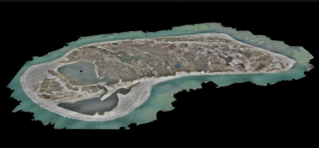
Case Study: Muskeget Island
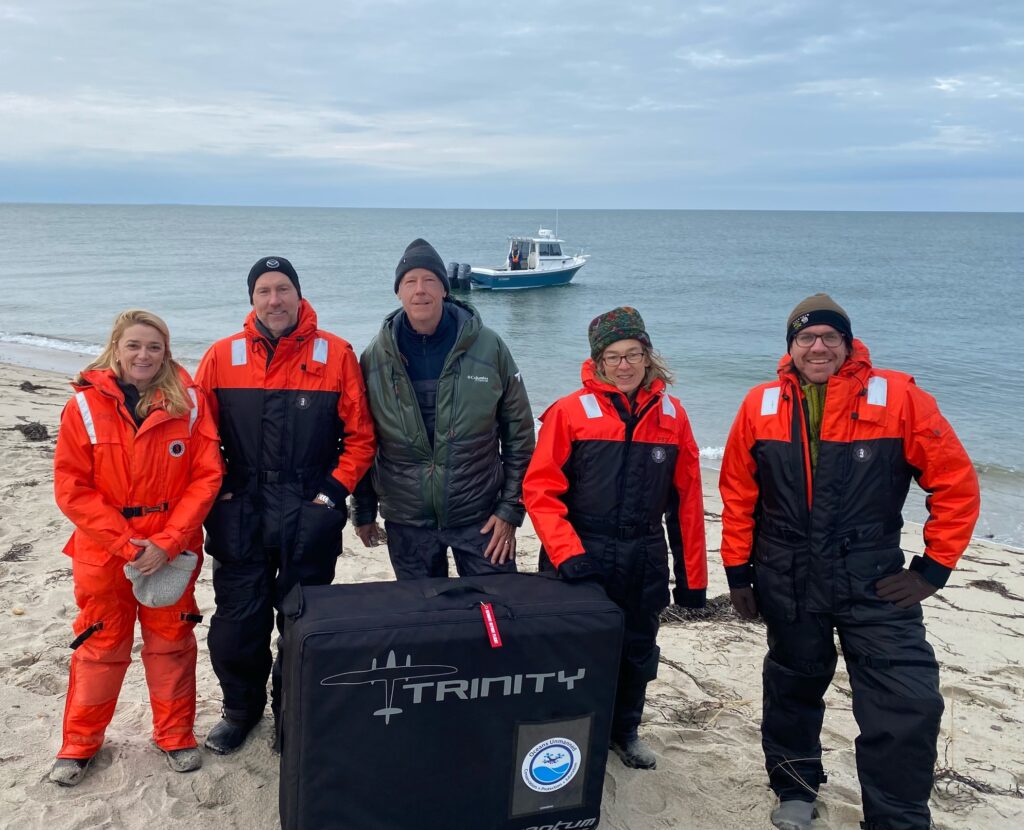
Kimberly Murray, a biologist who leads the Seal Ecology and Assessment Program at NOAA’s Northeast Fisheries Science Center in Woods Hole, is working with Oceans Unmanned to better understand the role of gray seals in the ecosystem.
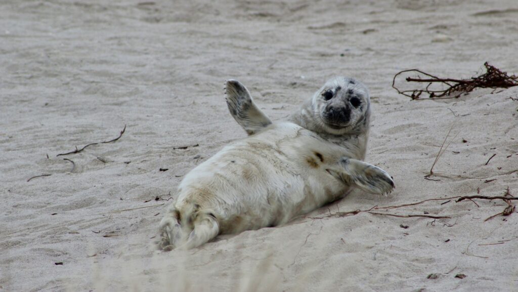
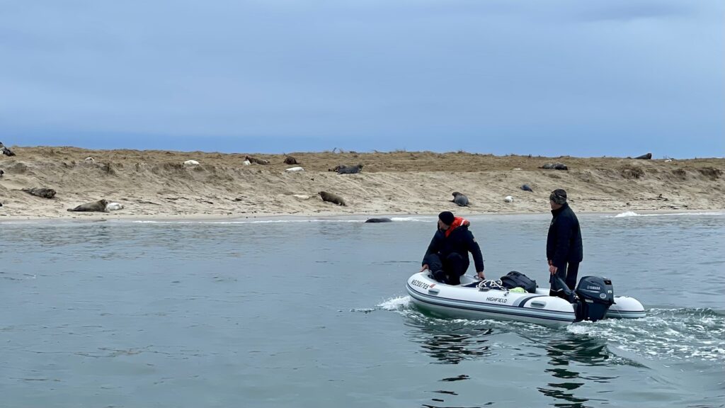
Each winter, with help from Brian and Matt, her team surveys Muskeget Island, home to one of the largest gray seal pupping colonies in the entire western North Atlantic. “And it’s only on this one-square-kilometer island,” Kimberly says.
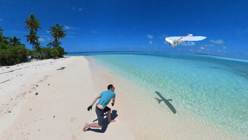
Using a drone, which takes off vertically before transitioning into an efficient fixed-wing aircraft, the team can survey the whole small island in high resolution in about ninety minutes. “It’s a really useful tool to monitor trends in abundance at that site and the rates of increase in the number of pups that are born each year in the population,” Kimberly says. “We try to target at peak time, after all the pups are born, which is usually early January.”
“The gray seals are increasing,” she says. “We know from measuring the number of pups born each year. A lot of that is driven by immigration from Canada. Some animals that were born in Canada are now having their pups in the U.S., and once they do that, they tend to come back to the same island to have their pups again.” The population in the U.S. portion of the Western North Atlantic was estimated at roughly 27,000 seals as of the most recent abundance estimate in 2016.
“Overall, I think that’s a sign of a healthy marine environment, because we have suitable habitat and an environment rich enough to support that growth,” she says. “It does come at a social cost to the people who interact with seals on shared beaches, or fishermen who are trying to make a living. And white sharks venture into that picture there too, because they are obviously now near parts of the Outer Cape foraging on seals, when historically they weren’t here in large numbers.”
“As we overlap more and more with the recovering population, we’re trying to work out how to coexist with that,” she continues. “The drones have been a really great tool in helping us understand the rates of growth, and coupled with information on movements and distribution, we can also get a sense of what kind of habitat these animals are using and where they might be coming into conflicts with the public.”
Her team also uses smaller, “hexacopter” drones for studying individual animals. “We can get better imagery of, say, that animal’s mass, or whether or not it might have health issues like an entanglement, or any marks, brands, or tags existing on the animal already,” she says.
The team is even experimenting with getting volumetric data on individual animals. “If you fly a certain pattern, you can create a 3D image of the seals. If you can get an idea of their length and weight and their body condition, you might be able to assess whether or not that’s changing over time in the colony, which could be an indicator of changes in the environment,” she says.
Some challenges remain; because drone pilots still need to have line-of-sight proximity to their equipment, the team still needs to physically set foot on this small island in winter.
“Leaving from Woods Hole to go over to a little island off Nantucket in January in a twenty-five-foot, center console, open-air boat, in your Mustang suit… it’s a little hairy sometimes,” Kimberly says. A future scenario where a drone could fly round-trip from Nantucket would be “a much safer mission,” she adds.
Still, she says, “I never would have imagined that we would be flying drones over animal colonies to study not just numbers, but their particular characteristics.”
What you can do:
- Check out the Oceans Unmanned website and on X (formerly known as Twitter), where they post about ongoing research. Watch them look for Marbled Murrelets in Oregon.
- Read more about Kimberly Murray’s research on seal ecology on NOAA’s website.
- Be responsible with personal drones — these can be very stressful on wildlife like nesting birds, and many protected areas have strong restrictions on their use. Here are Oceans Unmanned’s drone guidelines.